
So you may have noticed that I haven’t posted many visits lately. This is because our fall trip to New Mexico fell through due to life things so I missed my 11 parks that I had planned to do with the kids. Now my husband says “11 parks alone with the kids??? Are you crazy??” Yes, yes I am, crazy like a fox! With planning you can actually make your drive much easier by hitting National Park sites. I have found no easy way to actually locate the parks with navigation, I tried roadtrippers.com but it was pretty buggy and missed lots of the sites, additionally I couldn’t seem to get it to differentiate between NPS sites and all other kinds of sites. Though, I did find it useful when I wanted to see things like “Biggest Ball of String.” So this is my method.
I start with google maps and put in my start and end destinations. Then I pull up this NPS map. It is available here https://www.nps.gov/hfc/carto/PDF/NPSmap2.pdf

Eyeballing Google’s “best route” to my destination I find the first closest NPS stop and decide if we’ve seen it. Because we mostly travel west they are almost always in Ohio. Lately though, I have been trying to save the closest stops so we can do weekend mini trips. So I try to find a stop between 4-6 hours away to check out. That is the maximum time I can expect the kids to have before they get out for at least and hour, and closer to 2 is better. Our first stop usually indicates how we are crossing country, we alternate latitude when we cross since we are almost always driving to Albuquerque. That way we see more of our beautiful country.
Once I choose a first stop I add it into Google Maps and I check how much time it adds to the trip. It’s not helpful if it adds 6 extra hours but doesn’t advance us West, or whatever direction we are headed. I do this stop by stop. You can add up to 10 stops in Google Maps. It does get a little tedious, and I 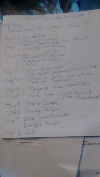 find it necessary to keep a clipboard and pen next to me in order to tabulate it. The perfect day for me is to wake up and breakfast at the hotel, on the road at 7:30 am, 4 hour drive to a park site, lunch and site (2-3 hours), 4-5 hours of driving, dinner and hotel. This minimizes child anger for us and still allows 8-9 hours of driving without being too rigorous. Obviously not all parks can be done in a short time and deserve more time, you may be able to see that in this picture that I left 3 days for the Grand Canyon in an upcoming trip, hardly what it deserves for such grandeur. But I will probably end up cutting it back because realistically we can’t hike much of the canyon with the kids, we just aren’t those people and we don’t have those kids. But we will still appreciate it’s beauty. When the kids are older Ranger and I will be able to do some of the more in depth hikes and really enjoy the big parks, but Lemon is never going to be that girl, and neither is her father. So I work my way across the google route, cross referencing and adding stops using the NPS map, and tabulate it all on paper so that I have the correct gaps and see how long it will actually take. I wish there was a better way but if there is I haven’t found it! Then I add time back in because I am notorious for over scheduling. THOUGH I will say that this particular trip looks incredibly LEISURELY to me!
Once I have a plan I like I fill in all the hotel stay holes by finding hotels. If I am staying halfway between a park stop I find a small town to make a reservation. We have tried just going and finding a hotel enroute but it never really works, the hotels are too full, or too far apart or we end up in something scary. Sometimes we stay the night near the park, and do it in the morning. Or we did it in the later afternoon stayed near by and headed out in the morning. This tends to lead to a shorter driving day, middle of the day stops are really optimal. I also make a binder of all the stops and reservations, plus printed out google directions and when we leave we are all set, even if the internet fails! A cooler, and snack pantry are necessities because on these long trips it gets hard to feed everyone, both cost wise and pickiness. National Park sites are often out of the way in small places and sometimes the only options are fast food, which is okay for a meal, but on a long trip low quality food really grates on everyone. I find after eating those kinds of things for a few days everyone’s demeanor suffers. We love to eat at local spots but really full days make restaurants a tense experience for all of us and sometimes we just avoid the hassle.
For the car I generally prepare a book for each kid with a state map to color and coloring sheets for that state. Most you can find online with a search like “Illinois Coloring Sheets.” You will also find some things like state flower coloring sheets, famous historic figures or events, etc. Sometimes there are crosswords and word searches related to the state. Everything goes in the kid’s binder and I usually pull the relevant pages for the day and put them on a clip board. Each kid also keeps the Kids National Geographic Roadtrip Atlas in their car organizer. They take turns reading it and often pull it out unprompted when we cross a state line so they can regale us with facts about this state. Sadly for them we are both pretty trivia oriented and we get to say “Yeah, I knew that,” which is kind of funny for us. As my son has gotten older I will sometimes print short biographies, I have an excellent Wright Brothers one for when we head to Dayton Aviation NHP (hopefully this month! shhh don’t tell my husband.)
The best advice I can give is to also schedule more stops than you expect to do, always include a couple things that you can say “EHH, let’s just keep driving.” Being a little flexible is beneficial to everyone. Give yourself enough time at the bigger parks. Three hours is often plenty to spend at the historic sites, but the wilderness sites really often require more. I wish I had had more time at Cuyahoga, though it is easy to return, so I am not too put out over it. Also never ever stay at a hotel without a pool if you are road tripping with small kids. It IS always worth it to throw them into wet bathing suits early in the morning and spend 30 minutes splashing before forcing them in the car!

We’re working up a trip to get us from Michigan to Devil’s tower, and hit eight badges on the way. My husband thinks I’m insane, but he’s going to have a great time, you’ll see! ^_^
LikeLike
Devil’s Tower is a biggie! I am considering that for our 2019 trek which will have a more northern route. He will have a fabulous time!
LikeLike
Just so’s you know… we’re going to Cincinnati for X-mess (we always find one city we’ve never gone to, and spend our vacay days exploring, since we don’t celebrate like other people)… and YES, I’m doing the Taft badge, while we’re there…
But there’s another badge just north of there, and I knew we wouldn’t make it there, but I wanted to find out how involved it was. Turns out, it’s only open by appt, and so the badges are done on-line, from home. Maybe you already knew that, but if not, it’s a ‘freebie’ – in that it’s easy, and can be done without spending $$ to go there. ^_^
LikeLike
Oops… forgot to say it’s Charles Young Buffalo Soldiers Memorial.
LikeLike
Yes! Charles Young is only open by appointment only while they do the remodeling, but should have more regular hours in the Spring! I can’t wait to visit that one. Actually all the badges are available online, we just prefer to do them in person. Charles Young was such a huge figure in the protection of our National Park system, in addition to being an amazingly inspirational leader. I can’t wait to visit! It’s also very close to us so not too bad a drive. We may just head to Harper’s ferry soon and wait on Western Ohio until it’s open in the Spring.
LikeLike